


|
||

|

|
|

|
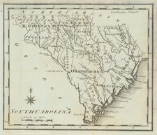
Joseph Scott's 1795 map of South Carolina, found in the first American Gazetteer, is an intriguing historical artifact. It's one of the earliest available American maps of the state, providing a snapshot of the geographic understanding of the time. It shows the state divided into nine districts, capturing the administrative divisions of South Carolina towards the end of the 18th century.
The map's key features are the districts it outlines. The Ninety-Six and Cheraw districts are particularly striking, delineated clearly but not yet labelled.
The counties, too, are depicted, though not comprehensively. This lack of uniform detail suggests that county boundaries may have been in flux or less significant to Scott's audience than the larger districts.
A notable point is the representation of the Tugaloo River, which is rendered as "Tugelo" on the map. This variant spelling provides an insight into the evolving language and place-names of the time. Such a discrepancy reminds us that language, like geography, is fluid, and maps can often bear witness to these changes.
The style of Scott's map is distinctly utilitarian, in line with the pragmatism of the late 18th-century cartography. It lacks the ornate flourishes found in earlier European maps but is nonetheless elegantly presented. Its stark lines and clear labels embody the Enlightenment's emphasis on clarity and rationality.