|
||

|

|
|

|
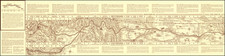
Great portrayal of the western United States, showing the extent of forested land at the end of the 19th century. Originally appearing in the 1898 edition of the USGS's annual report, this is a fantastic scientific portrayal of the extent of forests.
Two different shading types are used, with an apparent distinction between "wooded" and "forested" areas. "Forested" refers to the dense growths that exist in the Pacific Northwest and in the foothills of the higher mountains, while "wooded" refers to the sparse tree growth of more arid areas and some higher elevation forests. This information is printed on a base map that shows elevation contour lines, railroads, and rivers.
This folding map appeared in the Part V appendix to the Nineteenth Annual Report of the United States Geological Survey, which was subtitled "Forest Reserves."
"Cordilleran" refers to the extensive mountainous nature of the Western United States.

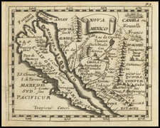
![Mexico [with Southwestern U.S., Texas, etc.]](https://storage.googleapis.com/raremaps/img/small/97606.jpg)