


|
||

|

|
|

|
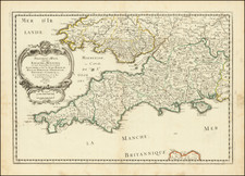
Sanson's double-page engraved map of Cornwall, Devon, the Isle of Wight, and southern Wales. Showing the geopolitical boundaries of the southwestern-most part of Great Britain, the map includes detail on rivers, cities, topographies, and forests. This copperplate was originally engraved by Nicolas Sanson, one of the most prolific French engravers of his time, during the mid-17th century and later printed in circa 1690.
The map shows the Kingdom of Wessex, apparently during the period immediately following the Heptarchy, in or around the 8th or 9th century. At the time, Wessex had finally concurred the Celtic kingdom of Dumnonia that occupied Cornwall, as shown on this map, and started its eastwards expansion. The Kingdom of Wessex would eventually become associated with the Kingdom of Mercia, and become the last Anglo-Saxon rulers of all of England.
Nicholas Sanson (1600-1667) is considered the father of French cartography in its golden age from the mid-seventeenth century to the mid-eighteenth. Over the course of his career he produced over 300 maps; they are known for their clean style and extensive research. Sanson was largely responsible for beginning the shift of cartographic production and excellence from Amsterdam to Paris in the later-seventeenth century.
Sanson was born in Abbeville in Picardy. He made his first map at age twenty, a wall map of ancient Gaul. Upon moving to Paris, he gained the attention of Cardinal Richelieu, who made an introduction of Sanson to King Louis XIII. This led to Sanson's tutoring of the king and the granting of the title ingenieur-geographe du roi.
His success can be chalked up to his geographic and research skills, but also to his partnership with Pierre Mariette. Early in his career, Sanson worked primarily with the publisher Melchior Tavernier. Mariette purchased Tavernier’s business in 1644. Sanson worked with Mariette until 1657, when the latter died. Mariette’s son, also Pierre, helped to publish the Cartes générales de toutes les parties du monde (1658), Sanson' atlas and the first French world atlas.

![[Annotated with Contempary Manuscript Sailing Directions] A New & Correct Draught of the Channell between England & France. . .](https://storage.googleapis.com/raremaps/img/small/80950.jpg)
![[France] Antiquorum Galliae Episcopatuum Geographica Descriptio . . . 1640](https://storage.googleapis.com/raremaps/img/small/82032.jpg)