


|
||

|

|
|

|
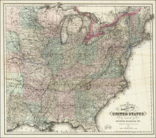
Geological map of the United States, published by O.W. Gray.
The map exhibits the geological regions, including Eozoic, Silurian, Devonian and Lower Carboniferous, Coal Measures and Permo-Carboniferous, Triassic and Jurassic, Cretaceous, Tertiary, Alluvium and Volcanic, each coded by color.
Particularly curious is the fact that the boundaries between strata is not delimited in the print, but solely up to the technical skills of the colorist to delimit. While common practice is to print at least some for of an indication of where to draw the strata, it is not unheard of for the colorist to be left to copy the map without aid.
The many features of the geology of the United States are readily visible. In Nevada and Utah, the lines of early strata stretching out north-south from plains of younger material is very typical of the Great Basin. In the east, the Appalachians lead to the wavy bending and folding apparent. The midwest has moure rounded shapes, representing the little-deformed interior of the North American craton.
O. W. Gray was a publishing firm based in Philadelphia. Later, they published as O. W. Gray & Son. They published atlases in the late nineteenth century. Gray's National Atlas was one of the most successful commercial ventures of the 1870s and one of the last to employ hand coloring on maps.


![Gen. Washington [On The Battlefield At Trenton] Engraved by W. Warner from the original picture by Col John Trumbull](https://storage.googleapis.com/raremaps/img/small/103233.jpg)