|
||

|

|
|

|
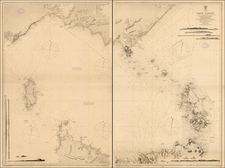
Nice early regional map of the area centered on Australia, which includes hundreds of islands and nice detail in Australia and New Zealand. This map was published by Sidney Hall in London as part of his “A New General Atlas Constructed by A. Arrowsmith, Hydrographer to the King."
The map includes early detail on the coastlines of Australia and New Zealand. Of particular interest is the note in the southeast of Australia suggesting that the Macquarie River is supposed to flow across the entire continent through to the western coast of Australia. A note in the lower left mentions the Kerguelen Islands and their location.
The General Atlas. . .was first published in 1817 and was reissued a number of times afterward. The maps included are noted by David Rumsey as particularly dense with information.
![Isles de Salomon [Early depiction of New Zealand!]](https://storage.googleapis.com/raremaps/img/small/101683.jpg)

![[Hunter Island / Tasmania] Carte Trigonometrique des Iles Hunter dressee Par L. Freycinet, Commandant le Casuarina -- December 1802 (Rare Separately Published Example)](https://storage.googleapis.com/raremaps/img/small/53937.jpg)