|
||

|

|
|

|
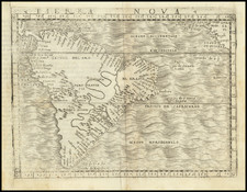
Extremely rare map of America, published by Clement de Jonghe. California is an Island. Only one Great Lake is shown. The Rio Grande flows into the Gulf of California. Catalina Island is named, as is San Diego. Excellent detail along the East Coast of North America and the Gulf Coast, with a very curious pair of rivers, extending from the Gulf Coast to the Midwest, including an interconnect. A number of Indian Tribes and Pueblos are named in the Southwest. The map is derived from Dancker Danckerts map of 1661, which drew from DeWit's rare carte-a-figures map, but extends further north, introducing Baffin's Bay. The coast of America has been improved to include details from Blaeu's Paskaert, including a more recognizable Long Island. Burden notes that De Jonghe was an art and book seller, who sold composite atlases. Hi's maps are of the utmost rarity, with only two known examples of De Jonghe's atlases in institutional collections. Burden notes that all editions of the map are very rare. Burden 362, State 2. This example has been cleaned and backed on linen with some restorations in the lower corners. Still, a beautiful example of a cartographic rarity. McLaughlin 31.
![La Florida [with] Guastecan [with] Peruviae Avriferae Regionis Typus](https://storage.googleapis.com/raremaps/img/small/89451.jpg)
![[Portrait] L'Amerique.](https://storage.googleapis.com/raremaps/img/small/79745.jpg)