|
||

|

|
|

|
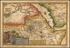
The Founding of the Second Saudi State
This scarce map documents a series of battles that occurred during the Nejd Rebellion, which persisted from 1821 to 1824 and was fought between Egyptian forces and adherents to the Wahhabi movement on the Arabian peninsula. This movement was responsible for the rise of the House of Saud starting at the end of the 18th century, and this conflict would result in the Emirate of Nejd, also known as the Second Saudi State.
The map shows the region between Taif, just east of Mecca, down through Tabab, and slightly into northwesternmost Yemen. The path of military leaders is shown and demarcated and notes relay troop movements between 1824 and 1825. Topography is shown along the regions in which Ritter was able to gather data, and a number of towns and geographical features are shown.
In the lower part of the map, a number of insets show early pictorial figures and drawings made on cliff faces and cave walls from Yemen. The outside of two caves holding a sepulcher and a floor plan of this tomb is also shown. Yemen and the part of Saudi Arabia shown are renowned for their abundance of early historical artefacts, and Ritter was fascinated by this part of the region's history.
This was published by the eminent German historian, Carl Ritter, in the first half of the 19th-century. Carl Ritter is considered one of the founders of modern geography and was an important figure of his time. One of Ritter's best-known works, his Erdkunde im Verhaltnis. . ., attempted to describe the geography of the entire globe. This work had a very broad concept of geography, not only encompassing cartography but also hydrography, climatology, and volcanology. Ritter never completed his work due to the vast scale of his undertaking.