


|
||

|

|
|

|
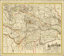
Scarce map of the area from Antibes, Nice, Monaco and Vintimiglia on the Mediterranean to Le Valle Protestestanti, Pinerolo, and the source of the Po and Durenza Rivers in the Maritime Alps. This map originally appeared in Rossi's rare Mercurio Geografico.
The map is a tremendous example of the fine topographical style of Rossi's maps, elegantly tracing rivers through steep defined mountain valleys. The map includes a key in the lower-left that depicts the symbols used on the map for towns and settlements of various types.
This map was based on the cartography produced by Giacomo Cantelli da Vignola, who was court cartographer to Francesco II d'Este, Duke of Modena, at the time that this map was produced.
Giacomo Giovanni Rossi (1627-1691) was an Italian engraver and printer. He worked in Rome, the heir to an important printing business founded by his father, Giuseppe de Rossi (1570-1639). Giuseppe began the press in 1633 and Giovanni and his brother, Giandomenico (1619-1653) took it over upon his death. The brothers expanded the business and by the mid-seventeenth century it was the best-known printing house in Rome.
For his maps, Giovanni worked with Giacomo Cantelli da Vignola. They produced the Atlas Mercurio Geografico. The first edition is undated, but the second was issued in 1692, a year after Giovanni’s death. The maps were by Cantelli. The firm also published maps based on those of Nicolas Sanson.
Later, the business passed to Lorenzo Filippo (1682-?). By 1738, the firm was known as Calcografia Camerale, then, from 1870 to 1945, as the Regia Calcografica. Today, the firm is still in business and is called Calcografia Nazionale. It operates as a free museum and offers one of the best collections of prints and plates in the world.
![[Goro / Po River] The Port of Goro](https://storage.googleapis.com/raremaps/img/small/73588.jpg)
![[ Parma and Modena ] Carte Des Estats de Parme et de Modene avec la partie orientale de la riviere de Genes. . . 1779](https://storage.googleapis.com/raremaps/img/small/101045.jpg)
![[Vercelli] Urbis Vercellensis a Carolo Emmanuele II](https://storage.googleapis.com/raremaps/img/small/89098.jpg)