|
||

|

|
|

|
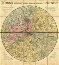
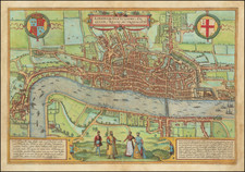
Finely colored example of this early state of this important map of London, illustrating the zones of delivery for goods around London.
An expansive and detailed map of London, produced for the transportation of goods at the turn of the century. Detail on the map is very extensive, with thousands of streets, parks, railways, buildings, and more all labeled. The map accompanies a fifty-two page index of street names.
London is visible on the map from Barnes to Ilford, an expansive area. Despite this, the large size of the map allows for a rare rivaled view of the city. The map is clearly designed for delivery purposes. Railway depots are shaded, and stations that accept goods are labeled. Receiving centers for some institutions, such as the Humane Society, are marked
The most obvious feature on the present map are the color codes around London; these are the "Collection & Delivery Boundaries" the map is referring to. Historical references to such boundaries are few and obscure. It appears that, at the time this map was produced, "goods cartage fees" were applied to any goods being shipped from between cities. This applied to train companies, and perhaps other methods of goods transport as well. Why two lines are shown on this map is uncertain, perhaps they represent a discrepancy between the boundaries for delivery and collection or different rates.
A 1924 map shows only one line, the blue line presently mapped, perhaps indicating that both lines became merged at some point, or the pink line became obsolete. It appears that these lines are standardized across the industry, and were most likely set by the government. It appears that these goods cartage fees are not just confusing to later observers: an 1874 court case goes into depth about how fees are charged and the legality of these charges applied at boundaries.