|
||

|

|
|

|
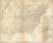
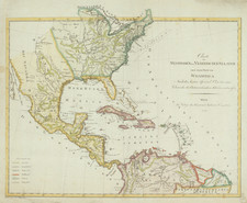
Custom Assembled Map of the United States at the Time of the Louisiana Purchase with Notes From an Early French Traveller
Richly embellished and hand annotated example of the first state of Pierre Tardieu's wall map of the United States, with a specially prepared additional flap showing Florida, drawn from a map of Florida by the Depot de la Marine, with clever modifications.
Tardieu's map is based upon the true first state of Arrowsmith's map of the United States, which has been completely re-engraved by Tardieu, and reflects the finer engraving skills of this Paris engraver. In addition to the decorative cartouche present in Arrowsmith's map, Tardieu has added a plan of Washington DC, based upon Andrew Ellicott's official plan for America's newly minted Capital City.
The map is a landmark of American Cartography prior to Lewis & Clark. The interior detail of the trans-Mississippi west was compiled largely from accounts supplied by Native Americans to Arrowsmith, by the Hudson's Bay Company. The course of the Missouri River delineated on the map prompted Lewis and Clark to plot their course along the Missouri River, as it appeared to be the most direct route to the Pacific. This is the first edition of the map.
The present map came to the attention of Thomas Jefferson, who specifically reached out to the Tardieu family to update the map. The Tardieus family exchanged maps with Thomas Jefferson on several occasions, specially in aid of the Tardieu's efforts to incorporate information from Lewis & Clark and others into their maps (see, e.g. letter from P.A.F. Tardieu to Jefferson dated May 30, 1809. www.loc.gov/item/mtjbib019962/ ). Thomas Jefferson wrote to Tardieu on one occasion, thanking him for his excellent maps of the United States and the Bay of Mexico, and in return, Jefferson sent Tardieu a survey of the Mississippi River from its source to the mouth of the Ohio, and promises a map of Louisiana from "Gov. Lewis, who conducted the journey to the South Sea as soon as it appears."
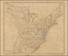
Manuscript Additions and Printed Florida Flap
The map is richly annotated with a number of notes, some of which appear to be eye witness notes, potentially those of an early traveller. The most interesting notes are concentrated in the Western and Southern parts of the map, the areas which would have been of the greatest interest to the French immediately before the Louisiana Purchase. These include a number or routes drawn onto the map along the Gulf Coast, Mississippi River and in the region between the Mississippi and Ohio Rivers, and several notes that read like personal observations about distances and terrains, such as the note on the White River, between the confluence of the Mississippi and Arkansas Rivers.
Riv. Blanche qu'on a remonte` a 70 lieues ? ? barques plattes
White River where we paddled back up stream for 70 lieux with some flat boats.
While the annotations are undated, we suspect that the notes were added immediately before or shortly after the creation of the State of Ohio on February 19, 1803, as the location of the annotations suggests that the boundaries of the Northwest Territory were still under consideration, suggesting a date of 1802 to early 1803, consistent with the time period during which the Louisiana Purchase was being negotiated. This would explain the inaccurate location of Florida and annotations focused on the regions of the map most impacted by the Louisiana Purchase negotiations.
The map and additional flap are thoroughly annotated throughout, the work of an astute contemporary observer. Virtually every region was embellished. The following is a brief summary:
- Spanish East and West Florida
Several coastal features are added, but most notably, there are numerous Indian reservations, Spanish Forts and improvements of the courses of rivers.
The course of the St. Johns River is added and connected to the flap, with several Spanish forts added and the word "Ivitanca" (?) appears near Jacksonville, Florida, along with a number of roads in the area. This may be a reference to Wacca Pilatka or Cow Crossing.
- North & South Carolina / Tennessee
The map shows a Canal between the Edisto River and the Ashley River. The General Assembly of South Carolina passed, in 1785, "An Ordinance for clearing Edisto" and other rivers, and two years later. established a "Company for clearing and improving the navigation of Edisto and Ashley Rivers, and for forming a communication by a canal and locks between the former and the latter." The Edisto and Ashley Canal project was the subject of three petitions between 1801 and 1809. (Downey, Planting a Capitalist South Masters, Merchants, and Manufacturers in the Southern Interior, 1790–1860. . . (2009)). The Edisto & Ashley River Canal Company seems to have been chartered in about 1786 and active from about 1787 to 1809, and seems to have included prominent investors.
- South / Louisiana
A road is shown from Cowetas (Coweta Town) on the Chattahoochee River to Fort Conde on Mobile Bay and then on through Pascagoola, New Orleans, Manchac (Fort Bute), then up the Mississippi to the Vicksburg area and then to Nashville on the Cumberland River. In this region, the writer shows a number of Indian Villages west of the the Little Yazoo River, identifies the location of the Ancient French Fort (Fort Rosalie), built in 1716 and abandoned following the Second Natchez War, after a massive attack in November 1729 by the Natchez against the allied French and Choctaw.
A lengthy note to the west of Lake Pontchartrain notes the frequent inundation of the marshlands in the area. The pilot house at La Balise at the mouth of the Mississippi is also noted. A note about the wandering Indians around Mobile Bay is included.
Further north in northern Alabama and Mississippi, vast plains with tall grasses are noted.
- Illinois / Missouri River / Upper Mississippi River / Indiana / Ohio / Great Lakes
Several notes appear at the confluence of the Arkansas and Mississippi Rivers.
Near Kaskaskia, Illinois, a road is shown across the "Northwest Territory or State of Ohio", meeting up with the road from New Madrid just south of St. Vincennes and extending north towards along the Wabash to the Weautenan (Ouiatenon) Villages (location of the French Fort Ouiatenon, establish in 1717), where it meets up with printed roads.
The ancient fort and Villages of the Peorias is noted. A note on the Missouri River shows that it is navigable for 400 Leagues. North of the Missouri River, a vast area of Buffalo is noted.
Detroit, Fort Detroit and "Malden" are added on the Detroit River.
There is a note about the Thames River, to the west of the London, Ontario with a section of the Thames river marked out.
At the area where Lakes Huron and Superior Meet, Fort. Ste. Marie, I. St. Joseph and F. Anglais (English Fort) are noted.
- New England / Northeast / Eastern Canada
Frederick's-Town (Fredericton) is shown on the St. John River in New Brunswick.
Bay of Burlington (Lake Ontario), Ft. Chippawa, Cananwaga, Ontario are noted in Western New York State.
Ancient Fort Duquesne is noted.
Rarity
The Tardieu map is scarce, especially the 1802 edition. The addition of the Florida flap and annotations make this a unique survival.
Pierre Antoine Tardieu (1784-1869), also known to sign his works as PF Tardieu, was a prolific French map engraver and geographer. The Tardieu family, based in Paris, was well known for their talent in engraving, cartography, and illustration. Pierre Antoine’s father, Antoine Francois Tardieu, was an established cartographer who published numerous atlases. His son is said to have collaborated with him for many years before establishing his own independent career.
Pierre Antoine Tardieu’s most famous work includes engravings of the islands of La Palma and Tenerife, for which in 1818 he was awarded a bronze medal by King Louis-Phillipe for the beauty and accuracy of his mapping. Other famous work includes his mapping of Louisiana and Mexico, engravings of Irish counties, maps of Russia and Asia, and his highly celebrated illustrations of all the provinces of France. He was also the first mapmaker to engrave on steel.
Tardieu was a popular map engraver in his lifetime, enjoying the patronage of the likes of Alexander von Humboldt and respect among his peers. In 1837, he was appointed the title Chevalier de la Légion d’honneur. As was written in his obituary in the Bulletin of the Geographical Society of France, he was renowned for his combination of technical talent and scholarly research skills and praised for furthering his family’s well-respected name in the scientific arts.
![United States of America [with] The Course of the River St. Laurence from Lake Ontarion to Manicouagan Point](https://storage.googleapis.com/raremaps/img/small/71643.jpg)