|
||

|

|
|

|
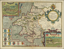
Very attractive map of England and Wales, published by the prolific French engraver Nicolas Sanson in the middle of the 17th century. This historical map fantastically shows the Heptarchy period of the British Isles, the early Anglo-Saxon division of southern Great Britain.
Existing from the 5th to the 8th centuries, the Heptarchy represents the seven Anglo-Saxon kingdoms of England, most of which have later given their names to British regions. The main kingdoms were East Anglia, Essex, Kent, Sussex, Wessex, Mercia, and Northumbria, with several additional minor kingdoms also existing. The relative powers of these nations changed frequently, with an early domination of Kent in the 6th century giving way to Northumbria and Wessex in the 7th century. In the 8th century, the heptarchy was consolidated into four surviving kingdoms.
This map colors regions according to the region they belong to. The names of modern cities are given. Parts of Scotland, Ireland, France, and the Isle of Man are visible.
Nicholas Sanson (1600-1667) is considered the father of French cartography in its golden age from the mid-seventeenth century to the mid-eighteenth. Over the course of his career he produced over 300 maps; they are known for their clean style and extensive research. Sanson was largely responsible for beginning the shift of cartographic production and excellence from Amsterdam to Paris in the later-seventeenth century.
Sanson was born in Abbeville in Picardy. He made his first map at age twenty, a wall map of ancient Gaul. Upon moving to Paris, he gained the attention of Cardinal Richelieu, who made an introduction of Sanson to King Louis XIII. This led to Sanson's tutoring of the king and the granting of the title ingenieur-geographe du roi.
His success can be chalked up to his geographic and research skills, but also to his partnership with Pierre Mariette. Early in his career, Sanson worked primarily with the publisher Melchior Tavernier. Mariette purchased Tavernier’s business in 1644. Sanson worked with Mariette until 1657, when the latter died. Mariette’s son, also Pierre, helped to publish the Cartes générales de toutes les parties du monde (1658), Sanson' atlas and the first French world atlas.
![[ Oxford and Windsor Castle ] Oxonium nobile Anglie oppidum Septenrionalem . . . [with] Vindesorium celeberrimum Anglia castrum locus amoenißimus aedificia magnifica . . .](https://storage.googleapis.com/raremaps/img/small/96906.jpg)
![[ Northern England ] Die Koenigreichs England nordlicher Theil oder York Shire, das Bisthum Durham, Northumberland, Cumberland, Westmoreland und Lancashire . . .](https://storage.googleapis.com/raremaps/img/small/103743.jpg)