


|
||

|

|
|

|
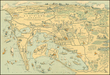
Great whimsical map of San Diego County, showing a host of activities throughout the county, with a larger city street map. The pictorial map of San Diego is remarkable and shows all of the hallmarks of what has now been termed the golden age of American pictorial maps.
Among the more timely inclusions in this map are the baseball field next to the county administrative offices and Balboa Stadium, next to San Diego High School. Camp Callan, the old anti-aircraft training center, is shown near the La Jolla gliderport. A ferry takes passengers from San Diego to Coronado.
Two variants of this map are known to exist, one of which contains additional detail of several activities which can be undertaken throughout the county. This may be a slightly earlier edition, with less detail shown in La Jolla, including the lack of a biological institute.
In all, a fantastic pictorial map of San Diego.
![[ Pacific Northwest - Northwest Passage ] Limes Occidentis Quivira et Anian. 1597](https://storage.googleapis.com/raremaps/img/small/71207.jpg)
![[ Lake Tahoe - Placer County Atlas ] Map of Revenue District No. 3, Placer County](https://storage.googleapis.com/raremaps/img/small/100236.jpg)