|
||

|

|
|

|
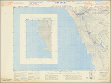
Detailed military survey map of the area around El Alamein Station, stretching off to the south, and showing the area just before the famous Second Battle of El Alamein, which took place between October and November 1942.
The map shows the area where the Allies broke through Axis armor. The Battle also extended to the south of this map's coverage.
The map was compiled from survey by 512 Army Field Surrey Coy R.E. and South African Survey Coy., and was drawn and printed by South African Survey Coy. August 1941. Reprinted with minor revision by Litho. Sec. M.M.P. and P. Coy. S.A.E.C. att. 46 Survey Cov. S.A.E.C. July 1942. Recast sheet printed by 46 Survey, S.A.E.C., August. 1942.
A key on the back is very extensive, labeling: Railways; Railways with Telephone Lines; Telephone Lines; Macadamized Road (with Kilo. Post); Motor Tracks; Camel Tracks; International Boundary Numbered Beacons; Frontier Wire; Pipe Line; Wells; Cisterns; Wâdis; Sabakha (Salt Marsh); Marsh; Sand or Wadi Bottoms Cliff; Rock; Contours (The top of each contour number is on the uphill side of the contour. Thick Lines at 25 m. Vertical Interval); Trig. Point (With Height); Spot Heights; Houses; Ruin; Sheikh's Tombs; Graves; Mounds; Cairn; Fig Trees; Palms; Scrub; Cultivated Areas.
The mention of "Sheiks Tombs" is particularly intriguing. There are notes on the map about "Good Going" and "Firm Going".