|
||

|

|
|

|
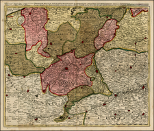
Attractive original antique map displaying the conquests made by Louis XIII and the lands taken from the Germans. Showing Alsace and Swabia, the map includes attractive and extensive detail in Guillaume Sanson's French School style. The map was published in 1666 in Paris.
The work, an overt flattery which is dedicated to "his most Christian majesty" by "his very humble, very obedient, and very loyal subject," refers to the events of the Franco-Spanish War of 1635-1639, fought by Louis XIII and XIV, in which Alsace was first taken in 1639 from the Spanish Hapsburgs. The end of the war represented the height of the Sun King's power, and this map seeks to remind the populace of his exploits.
The son of famous French cartographer Nicolas Sanson, Guillaume (1633-1703) carried on his father's work. Like his sire, he was a court geographer to Louis XIV. He often worked in partnership with another prominent cartographer of the time, Hubert Jaillot.
![Montes, Hannoniae Metropolis [and] Atrebatum, Episcopalis Et Metropolica Artesiae Citivas](https://storage.googleapis.com/raremaps/img/small/41468mp2.jpg)
![[Artois] Comitatuum Artesiae Boloniae et Guines Novissima Descriptio](https://storage.googleapis.com/raremaps/img/small/78978.jpg)
![[Rhine River Region -- Basle to Strassbourg]](https://storage.googleapis.com/raremaps/img/small/75325.jpg)
![[Calais] Chales](https://storage.googleapis.com/raremaps/img/small/61280sb.jpg)