|
||

|

|
|

|
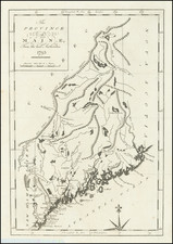
One of the Earliest Maps of Maine Published Outside America
Finely engraved early map of Maine, hand colored by counties.
Roads, towns, rivers, and lakes are included on map. Key notes flags for 10 remarkable battles.
Size includes text surrounding map, which includes wonderful contemporary details concerning the topography, indigenous lands, rivers, climate, towns, manufacturing, commerce, education, history, population by county, and other information. .
Buchon follows the format of Carey & Lea's Atlas, which is highly prized not only for its cartographic information but the marvelous information about each of the states and territories included. The atlas was issued in 6 editions in English, French & German between 1822 and 1827.
The French edition is generally the most highly regarded, in terms of the quality of the paper and engraving.
Jean Alexandre Buchon (1791-1849) was a French scholar and historian. Born as the French Revolution raged, Buchon was dedicated to recovering France’s history in order to help the country heal and grow. He gathered French stories and published them as part of Collection des chroniques nationales franciases ecrites en langue vulgaire, du XIe au XVIe siècle (4 vols, 1824-1829). He also compiled and published an exploration collection and several histories, particularly about medieval France.
For geography, his most important contribution was publication of the French edition of Carey & Lea’s American Atlas in 1825. Each page of the atlas includes highly detailed text about the state or territory depicted, as well as a map of the area. The French edition is generally considered in high regard as compared to other editions, as it has quality paper and superior engraving.
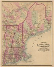
![[ Maiune ]. Railroad & Township Map of the State of Maine with Portions of New Hampshire New Brunswick and Canada . . . 1855](https://storage.googleapis.com/raremaps/img/small/100890.jpg)
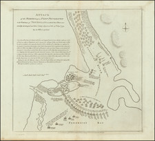
![[Portland & Cape Elizabeth to Moskito Island -- Centered on Kennebec River]](https://storage.googleapis.com/raremaps/img/small/50079.jpg)