|
||

|

|
|

|
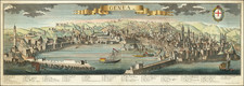
A fabulous town plan of Torino which includes three vignettes showing the Church of La Superga, a view of Turin, and the Royal Palace. The city is attractively laid out, with a grid-like structure and a citadel laying outside of the city walls. This is one of the most detailed plans of the town to appear in a 19th-century commercial atlas.
The many alleys, streets, and courtyards of Turin are readily visible. The city also has many parks, piazzas, and other open public spaces. Much of this center of the city is little changed today, with the Piazza Castello, Piazza Cararlo, and Giardini Reali still focal points of the city. The city barely reaches the Po on the map, although the vignette showing a view of Turin suggests that this might be slightly outdated.
Turin was, at the time, one of the most powerful cities in Italy. As the capital of the Kingdom of Piedmont-Sardinia, Turin led the way for Italian unification and would become the first capital of the Unified Kingdom of Italy. In post-war and contemporary Italy, Turin is known for being an industrial center and the headquarters for Fiat.
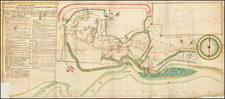
![(Jerusalem - Temple of Salomon) Templum Salomonis [with Perugia on verso]](https://storage.googleapis.com/raremaps/img/small/96662.jpg)
![[Milan World's Fair] Milano 1906](https://storage.googleapis.com/raremaps/img/small/89259.jpg)