


|
||

|

|
|

|
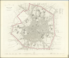
A detailed town plan of Milan, showing the fortified walls, city gates, inner ring, important public buildings, squares, and much more. Across the bottom lies a comparison of twelve of the most important public buildings in Milan, drawn to scale. This is one of the best maps available in a commercial atlas in the 19th century.
Milan, as portrayed, still lies well within the Spanish walls of the city in this depiction from the 1830s, though the city is rapidly expanding. The sub-symmetric layout of the city is easily noticeable, with the Sforza Castle laying along the axis of symmetry. Behind the castle, the present Sempione Park is named the Piazza d'Armi. Throughout the map, the important buildings of Milan are readily recognizable, including the Duomo. Parts of the walls are still surrounded by a moat. All which remains of this body of water in the present day is the small section in the Conchetta district, noticeable in the lower left of this map and labeled Darsena.
The buildings portrayed along the bottom of the map include the Duomo, Porta Romana, Royal Palace, and Bonaparte's Villa. In addition, some buildings no longer exist, such as the Lazzaretto (quarantine center), which was demolished in 1880. Surprisingly, the hospital of Milan still stands.
![[ Villa Farnese ] Caprarola Arx et Horti Farnesiani](https://storage.googleapis.com/raremaps/img/small/96849.jpg)


![Orvieto [with] Lauretum (Loreto)](https://storage.googleapis.com/raremaps/img/small/82089.jpg)