|
||

|

|
|

|
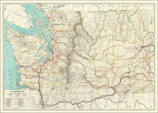
Rare Large Map of Western Washington
Rare W.H. Pumphrey map of Western Washington, prepared by Thomson & White and published in Seattle in 1892.
This is without question the largest obtainable map of the period, measuring approximately 52.5 x 33 inches and covering the region centered on the cascades.
The map is colored by counties and shows the extent of the public township surveys, early railroad lines, and some topographical features.
The map was produced during a period where the Pacific Northwest in general and Seattle, in particular, had experienced massive growth, primarily attributable to the expansion of the lumber trade in the Pacific Northwest. Issued 1 year after the Panic of 1893, the map captures the region during one of its greatest periods of expansion and real estate speculation.
Rarity
The map is extremely rare on the market. We note only the Babinski copy sold at Swann in 2005 ($2,880).
![[ Early Automobile Tourism -- Pacific Coast Highways ] (Strip Maps, etc.)](https://storage.googleapis.com/raremaps/img/small/81461.jpg)
![[ Used by '49ers To Travel To California ] Map of Oregon and Upper California from the surveys of John Charles Fremont and others authorities drawn by Charles Preuss 1848](https://storage.googleapis.com/raremaps/img/small/100557.jpg)