|
||

|

|
|

|
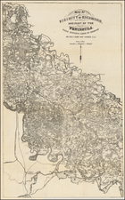
A scarce1872 map, titled "South Mountain," depicting the positions of the United States and enemy forces during the Battle of South Mountain, fought on September 14, 1862.
The battle involved the Army of the Potomac under the command of Major General George B. McClellan, facing off against the Confederate Army of Northern Virginia, led by General Robert E. Lee. The Confederate forces at South Mountain were commanded by General Howell Cobb, along with several other division and brigade commanders, who sought to defend key mountain passes and delay the Union Army's advance, providing Lee with valuable time to consolidate his scattered forces. The battle played a crucial role in shaping the subsequent Maryland Campaign, culminating in the Battle of Antietam.
The map was prepared by the Bureau of Topographical Engineers and provides a detailed representation of the battlefield's terrain, roads, and key landmarks.
The map includes a key that provides specific information about the positions of the U.S. forces, commanded by Major General William B. Franklin, and the enemy forces, commanded by Confederate General Howell Cobb, at 3:00 PM on Sunday, September 14th, 1862. The key also indicates the positions of the U.S. forces later that evening, at 5:00 PM, as the Confederate forces were in full retreat towards Sharpsburg.
The map's crisp black and white presentation allows for a clear visualization of the battleground, with various symbols and markings used to differentiate between the U.S. and enemy forces. This historical document serves as a valuable resource for understanding the troop movements and strategies employed during the Battle of South Mountain.
The map was produced using the American Photo-Lithographic Company's Osborne's Process, a technique that enabled the creation of high-quality lithographic reproductions of original maps and documents. This process contributed to the map's clarity and precision, making it an important visual reference for the events of the battle.
![[ Vicksburg Battle Plan ] Map Illustrating The Operations of the U.S. Forces Against Vicksburg.](https://storage.googleapis.com/raremaps/img/small/60302.jpg)