|
||

|

|
|

|
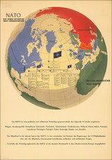
Fascinating World War II-era map prepared by the Central Publishing House of the NSDAP (Nazi Party) detailing some of the foreign policy preoccupations of the Nazis prior to the invasion of France.
The map was published between the invasion of Poland and the invasion of France, though a specific date is not given.
At the upper left is a map of the world showing the colonies of the major European powers. This was was during the period in which Germany was beginning to reassert its interests in places such as the South Pacific, where its colonies had been formally assigned to Japan after the First World War.
In the map of Africa, Germany claims the following colonies: Togo, "Kamerun", "Deutsch-Sudwest Afrika", and "Deutsch-Ostafrika".
The map at the right shows the Siegfried Line and the Maginot Line on the eve of the German invasion of France.
Additionally, there is a diagram labeled: "Verhältnis der Flächeninhalte des Mutterlandes zum Kolonialbesitz" or "Relationship of the area of the mother country to colonial property". This relates to a common complaint among German and Italian propagandists in the first half of the 20th century. Namely that England and other European powers had too many colonial possessions when compared to the footprints of the metropoles, that this was unjust, and that it naturally should be rectified (by taking new colonies or by taking colonies away from Britain and other European nations).
![(Second World War - Second Czechoslovak Republic) Malá, ale naša [Small, but ours]](https://storage.googleapis.com/raremaps/img/small/97457mp2.jpg)
![(Second World War - Postwar Reconstruction) [Archive of Materials Related to American Reconstruction Efforts in Bavaria]](https://storage.googleapis.com/raremaps/img/small/88055.jpg)