


|
||

|

|
|

|
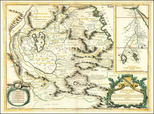
A striking example of Henri Chatelain's map of the Ottoman Empire, depicting the region controlled by Alexander the Great.
One of the few maps of this era to cover the whole of the Ottoman Empire, this large chart extends over the entire Mediterranean and includes Turkish possessions in North Africa. Extending from the Caspian Sea to include Persia and the Arabian Peninsula, the map covers most of southern Europe and northern Africa. Two inset maps including a smaller version of the map and a map of Macedonia and Greece. Great attention has been paid to the geographical features of the region and all the various mountain ranges and bodies of water have been carefully included.
The map is flanked by two large tables which provide a detailed list of the principal towns and states and give their exact location. There are lengthy historical notes on the Empire of Alexander the Great, as well as a wealth of information on the Roman Empire. The map appeared in Chatelain's monumental Atlas Historique.
Henri Abraham Chatelain (1684-1743) was a Huguenot pastor of Parisian origins. Chatelain proved a successful businessman, creating lucrative networks in London, The Hague, and then Amsterdam. He is most well known for the Atlas Historique, published in seven volumes between 1705 and 1720. This encyclopedic work was devoted to the history and genealogy of the continents, discussing such topics as geography, cosmography, topography, heraldry, and ethnography. Published thanks to a partnership between Henri, his father, Zacharie, and his younger brother, also Zacharie, the text was contributed to by Nicolas Gueudeville, a French geographer. The maps were by Henri, largely after the work of Guillaume Delisle, and they offered the general reader a window into the emerging world of the eighteenth century.
![Nova Europae Descriptio [Carte-a-figures]](https://storage.googleapis.com/raremaps/img/small/80435.jpg)
![[Cyprus, Holy Land, Syria, Arabia] Tabula Asiae IIII (with) Tabula Asiae III on Verso [Armenia, Georgia etc.]](https://storage.googleapis.com/raremaps/img/small/88877.jpg)
![[Portrait] L'Asie.](https://storage.googleapis.com/raremaps/img/small/79746.jpg)