


|
||

|

|
|

|
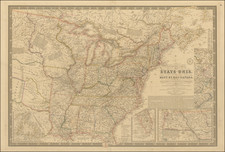
The Map That Launched The Mitchell Map Publishing Dynasty
Rare 1833 state of Samuel Augustus Mitchell's first separately published map, one of the great wall maps of the United States from this pivotal period.
Mitchell's wall map of the United States was the first cartographic production of the Mitchell family, which continued issuing maps and atlases under the name of the firm's patriarch, and his son Samuel Augustus Mitchell Jr., until the last decade of the 19th Century, a run of some 60 years.
Mitchell's map of the United States represented a firm leap forward in the modernity of American wall maps. Engraved with precision in Philadephia and reflecting a technical expertise not present in earlier decades of American map engravers, the details of the map is compelling. Mitchell also adds, for the first time on American wall maps, a series of inset maps of the major transportation hubs and metropolitan regions of the United States, including"
- Vicinity of Albany
- Vicinity of the Falls of Niagara
- Vicinity of Boston
- Vicinity of New York
- Vicinity of Philadelphia
- Vicinity of Baltimore and Washington
- Vicinity of Charleston
- Vicinity of N. Orleans
At the bottom right, a large inset map of North America shows Oregon Territory and Missouri Territory, the western region which were just then entering the consciousness of American westward expansion. Texas is named in the inset map five years before its Independence, with the towns of Galveston and S. Felipe de Austin reflecting the opening salvo of immigration from the US.
On the primary map Michigan Territory extends into what is today Wisconsin and Minnesota, which are labeled as "attached to Michigan." In the lower-left corner, there are comparative charts of mountains and rivers, as well as a statistical table for the states and territories of the United States.
Context: Mitchell's Career
Mitchell's first cartographic production was a re-issue of Finley's American Atlas in 1831, along with pocket maps from the Atlas. This first original map, engraved by J.H. Young, appeared in both case map and wall map format.
The first edition of this map was also published in 1831 and was updated.
State
To our knowledge, comprehensive cataloging of the states of this map has not yet been accomplished. There is significant attention to the 1831 first edition (see our examples or Rumsey 2723), oftentimes with the commentary noting the lack of delineated counties as the differentiating factor between the first state and those that follow. This is probably because Ristow (page 309), notes the 1834 state in which that information has been added.
This 1833 issue makes it clear that counties were not shown until 1834.
OCLC records examples of the 1833 at the University of Chicago, Library of Congress, Florida States, and the Buffalo & Erie County Public Library. The British Library has an 1839 issue.
For over fifty years, Samuel Augustus Mitchell, his son, and his successors some of the most prominent publishers of maps and atlases in the United States. Samuel Augustus Mitchell Sr. was born in Bristol, Connecticut on March 20, 1792. His father had emigrated from Scotland in 1773. While little is known about his early schooling, it is known that Mitchell found the quality of early geography text books to be lacking, and determined that he would write and publish better works. This decision led him to relocate to Philadelphia in 1829 or 1830, which was then the center of commercial publishing in America.
Mitchell’s first cartographic work was the re-issue of Anthony Finley’s New American Atlas in 1831, a work first issued by Finley in 1826, in response to Henry Schenk Tanner’s monumental work of the same title, issued in serial format from 1818 to 1822 and as a complete work from 1823 onward. While the map content in Mitchell’s edition of the New American Atlas is the same as Finley’s edition, each map has been significantly improved and revised, primarily with the addition of new towns and roads. This is especially true in the south and west. Finley had originally collaborated with D.H. Vance and J.H. Young in the preparation of the maps, although Vance’s name is removed from the Mitchell edition. Mitchell continued to work with Young, an association which would continue for several decades.
Following publication of the New American Atlas, Mitchell began issuing the individual maps in pocket map format. From 1834, Mitchell began offering reduced sized Tourist Pocket Maps of a number of states in the United States. J.H. Young and D. Haines are listed as the engravers on these maps. In 1832, Mitchell offered the first edition of his Travellers Guide Through the United States, A Map of the Roads, Distances, Steam Boat & Canal Routes &c. By J.H. Young . . ., which would become one of his most popular and enduring works. The map of the United States was done by steel engraving, one of the earliest uses of the technique in map publishing in America. In the same year, the first edition of Mitchell’s Map of the United States, by J.H. Young was issued, bearing the copyright date of October 10, 1831. This map would be revised and issued until 1844. Young also compiled A New Map of the United States in 1833. These two wall maps would come to dominate the market and their success led to several later US wall maps issued by Mitchell. This second map was also issued under the title of Mitchell’s Reference and Distance Map of the United States, which was printed until 1851.
Mitchell was neither a cartographer nor an engraver. His primary function was as the editor and business manager of his publishing company, with Young working as the primary maker of maps. Beginning in 1839, Mitchell also began publication of his school atlas. This work and variant editions for older and younger students, was issued by Mitchell and his successors from 1839 to 1886. In 1845, Mitchell acquired the rights to Henry Schenk Tanner’s New Universal Atlas from Carey & Hart, which had previously acquired the copyright from Tanner and had published editions of 1843 and 1844. Mitchell changed many of the maps and issued two editions of the atlas in 1846. He changed the copperplates to lithography, utilizing Peter S. Duval in Philadelphia to produce the stones. Mitchell re-issued the atlas at least annually until 1850, when he sold the rights to the work to Thomas, Cowperthwait & Company.
In 1860, Mitchell’s son, Samuel Augustus Mitchell Jr. began issuing Mitchell’s New General Atlas. While his father had continued to issue wall maps and other works, this appears to be his son’s first entry into the trade. The New General Atlas was issued by SA Mitchell Jr. until 1887. From 1880 to 1887, Bradley & Company also published the atlas. Various other minor publishers, including A.R. Keller, produced editions as late as 1894. The elder Mitchell died in 1868. Samuel Jr. continued the business until the 1890s. At its height, the Mitchell Company employed 250 people and sold 400,000 publications annually.

![[ Early United States Map ] Carte Des Etats-Unis De L'Amerique Septentrionale, dresse d'apres des Cartes Anglaises…](https://storage.googleapis.com/raremaps/img/small/39783.jpg)
![[ Atlas - Florida and Southern Canal Projects ] Travaux d'améliorations intérieurs projetés ou exécutés par le gouvernement général des États-Unis d'Amérique, de 1824 à 1831 [complete with:] Travaux d'améliorations intérieurs projetés ou exécutés... Atlas.](https://storage.googleapis.com/raremaps/img/small/85067.jpg)
![(Anti-Nato Propaganda) Военные Блоки-Оплот Милитаризма [Military Blocs-Strongholds of Imperialism]](https://storage.googleapis.com/raremaps/img/small/94274.jpg)