|
||

|

|
|

|
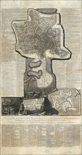
Fantastic and very rare antique engraved wall map of Rome, published in Rome by Matteo Gregorio di Rossi in 1680. This is the second edition of the map, the first of which was engraved by Matteo Gregorio but published by his father Giovanni Battista di Rossi in 1668. Stunning in its detail and extent, this is an impressive map and stands out as one of the great wall maps of the eternal city.
This highly decorative view of the city preserves great detail regarding the layout of Baroque Rome. On each block, a number of features are named throughout. Monuments are sketched, historical annotations are made, the landscapes of villas are depicted. Notes adorn the sides of the map, and decorations include a papal coat of arms, a view of the Tiber River, an oarsman holding a globe, and much more.
17th-Century Wall Maps of Rome
Jessica Maier, a noted historian of wall maps of Rome, says:
The representation of Rome is rife with examples. In the 1480s, for example, the Florentine engraver Francesco Rosselli published the first printed image of the city. That work does not survive, but its existence is known from an inventory, and it was the inspiration for a string of subsequent versions that reflected t same prototype—at least nine by 1569, by which time the derivatives perpetuate a thoroughly outdated picture of the Roman cityscape, still showing the Old St. Peter's perfectly intact and blithely omitting the Colosseum. Other formative maps of Rome from the early modern era, which might be termed "alpha" maps, include works by Leonardo Bufalini (1551), Mario Cartaro (1576), Antonio Tempesta (1593), Matteo Greuter (1618), and Giovanni Battista Falda (1676)—each of which spawned a long line of derivatives.16 This was a time when modern notions of plagiarism and intellectual property were inchoate at best, and copyright protection—in the form of printing privileges—limited and often unenforced.
Of the five 'alpha' maps Maier describes, the Rossi family map appears the most similar to the Falda map although its first edition predates the Falda map by some eight years. As such, it appears to be an important link in the development of the mapping of the city, and fills in the large gap between the Greuter and the Falda map. This is far from a simple derivative of the Falda map, which was reproduced without significant input by a number of 17th and 18th-century printers.
Rarity
The Rossi map of Rome is extremely rare. We find no examples having traded on the market, per RBH. We find one example of a late 1773 state that traded in Barcelona. We find only five examples of the map in OCLC.
![[ Celebration of the 12 Caesars in A Roman Triumphal Procession ] Ornatissimi Triumphi, uti L: Paullus de Rege Macedonum Perse capto, P. Africanus Aemilianus de Carthaginiensibus excisis; Cn: Pompejus Magnus ex oriente, Vespasianus, Trajanus, et alii Imperatores Romani Triumpharunt: ex vetustis lapidum, nummorum et Librorum monumentis accuratissima discriptio, Onuphrii Panvinii Veronensis inventoris Opera et aeneis formis Venetiis Ao. salutis MD. LXXX Greo: XIII](https://storage.googleapis.com/raremaps/img/small/89536.jpg)
![Veduta del Prospetto Principale della Colonna Antonina. [A Frontal View of the Column of Marcus Aurelius.]](https://storage.googleapis.com/raremaps/img/small/101718.jpg)