


|
||

|

|
|

|
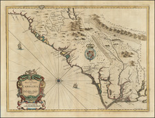
John Speed's A New Description of Carolina, engraved by Francis Lamb for the 1676 posthumous edition of Speed's A Prospect . . . of the World, stands as an important early map of the Carolinas, reflecting both the political ambitions of the era and the geographical myths introduced by explorer John Lederer. Based on the famous Lords Proprietors' Map of Carolina, this map embodies the complex interplay of exploration, colonization, and cartographical representation in the late 17th century.
The map's origin lies in Charles II's audacious grant to eight of his supporters, the Lords Proprietors, of all lands between Virginia and Florida, ignoring existing territorial claims. This political backdrop set the stage for the creation of this influential map. A young German explorer, John Lederer ventured across the Blue Ridge Mountains and introduced various geographical myths, including an erroneous description of Piedmont, North Carolina, a massive interior lake, and an arid region named the Arenosa Desert. These myths, perpetuated by Speed's map, survived in the cartographical record for nearly a century.
The map's depiction and design, drawn directly from John Ogilby's c.1673 map, include significant variations and details. Among these are the correct marking of Charles Town on the south bank of the Ashley River, a noteworthy early representation of Charleston before its relocation in 1680. The omission of the inset map of the Ashley and Cooper Rivers and other minor differences highlight the evolving understanding of the region. The map's engraving by Francis Lamb, coupled with the panels of text on the reverse derived from Ogilby's America, provides a multifaceted view of the region, enriched by an account of Lederer's travels.
In its historical context, A New Description of Carolina serves as both a document of territorial ambition and a reflection of the ever-evolving quest for geographical knowledge. The integration of political maneuvering, exploration, and cartographical innovation makes this map an essential piece of the 17th-century British colonial endeavor. Through its depiction of the Carolinas and the accompanying myths, it provides a glimpse into a time when the boundaries of the known world were in flux, shaped by the aspirations and imaginations of explorers and rulers alike.
John Speed (1551 or '52 - 28 July 1629) was the best known English mapmaker of the Stuart period. Speed came to mapmaking late in life, producing his first maps in the 1590s and entering the trade in earnest when he was almost 60 years old.
John Speed's fame, which continues to this day, lies with two atlases, The Theatre of the Empire of Great Britaine (first published 1612), and the Prospect of the Most Famous Parts of the World (1627). While The Theatre ... started as solely a county atlas, it grew into an impressive world atlas with the inclusion of the Prospect in 1627. The plates for the atlas passed through many hands in the 17th century, and the book finally reached its apotheosis in 1676 when it was published by Thomas Bassett and Richard Chiswell, with a number of important maps added for the first time.
![(The First Letter From British Florida) [September 5, 1763, Autograph Letter, Signed, from Robert Campbell to John Campbell, 4th Earl of Loudoun, describing the British taking possession of Florida and the state of the settlement of Pensacola]](https://storage.googleapis.com/raremaps/img/small/86620.jpg)