|
||

|

|
|

|
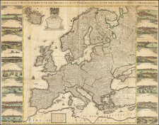
Striking English Wall Map of Europe -- Possibly a Unique Survival
Extremely rare four-sheet wall map of Europe bordered with exquisite city views on the left and right, published in London by Henry Overton in 1741.
Overton's wall map was intended for the English decorative market, an object to be hung in the library or salon of an English noble or wealthy merchant. While such maps were extremely popular in 17th and 18th century material culture in Europe and Britain, the vast majority of these wall maps were published in Paris and Amsterdam, a reflection of the relative nascency of the English map trade, even in the first half of the 18th Century.
Europe is densely filled with details of rivers, provinces, cities, and towns. The map stretches from Northern Africa to Scandinavia, from Lisbon to Moscow. Iceland is in the northwest corner, near the cartouche. The map itself seems to draw on a four-sheet map of Europe by Philip Lea, although it covers a smaller geographic area.
The cartouche includes the British royal coat of arms and a decorated frame with the title. There are compass roses in the Mediterranean and Atlantic, along with several sailing vessels. At bottom is another text cartouche advertising more wall maps by Overton, of the world and of England.
The importance of urban centers, and the beauty of the European city, is underlined via the views. On the left side are views of London, Rome, Paris, Constantinople, Amsterdam, Lisbon, Seville, and Antwerp. On the right are views of Venice, Stockholm, Frankfurt, Prague, Cologne, Copenhagen, Krakow, and Danzig. Both sets of views stress commerce, architecture, and mobility.
Maps with decorative borders were popular in the seventeenth-century, especially in the Netherlands and France. However, English examples, especially from this late date, are rarely seen.
We are able to date the map thanks to a mention of it on Overton's "A New & Correct Map of the Trading Part of the West Indies", state 2, which is dated March 25, 1741.
Rarity
The map appears to be very rare. We were unable to locate any other examples in OCLC. The only example offered at auction that we can trace was on sale at Sotheby's on June 27, 1991 (lot 294), re-offered June 25, 1993 (lot 104) and sold for $10,000.
The Overton family was a prominent part of the printing, and mapmaking, industry in London in the seventeenth and eighteenth centuries. John Overton (1639/40-1713) was the son of a tailor who apprenticed to Stationer Thomas Gould. He was made free of the Stationers’ Company in 1663. Two years later, London was struck by the Great Plague of 1665-6. Peter Stent, a leading printseller, succumbed and Overton took over his shop. This burned in the Great Fire of 1666, but Overton had rebuilt by 1669, when he advertised his wares from the White Horse on Snow Hill. Overton specialized in prints, portraits, and especially maps and topographical views.
John was likely married three times and had seven children. His eldest, Thomas, emigrated to America. His second oldest, Henry, was executor of John’s will when the latter died in 1713. Henry (1675/6-1751) acquired his father’s stock in 1707 and ran the shop until his own death in 1751. He published many maps, most focusing on the British Isles. His shop and stock passed to his nephew, another Henry, son of John’s fourth son, James.
Henry the Elder’s brother, Philip (ca. 1681-1745), was also a printer and mapmaker. Philip served as his father’s apprentice and was made free of the Stationers’ in 1702. His father set him up in the trade in 1707 and by 1710 he was working from the sign of the Golden Buck in Fleet Street. Philip specialized in fine arts prints, including Hogarth’s Hudibras set (1726), but he also sold many maps. At his death in 1745 he left his shop to his widow, Mary. She ran the shop and then married James Sayer, whose brother, Robert, became Mary’s assistant. He took over the business in 1748 and became a famous purveyor of maps, charts, and views.
Back at the sign of the White Horse, Henry the Younger continued the family business, expanding their stock to include a large collection of landscape views. He often partnered with Robert Sayer. He continued in business until at least 1764, when he drops out of the historical record.
![[Rare Complete Example with Game Pieces] Grand Circuit Des Capitales. Collection Concours Du Chocolat Menier](https://storage.googleapis.com/raremaps/img/small/70922rd.jpg)
![[ European Cooperation ] Organisation Europeenne de Cooperation Economique](https://storage.googleapis.com/raremaps/img/small/78837.jpg)
![(Hannibal Crosses the Alps) Expeditiones Hannibalis per Hispaniam, Galliam, Italiam, Africam &c. ex Plutarcho &c. . . . [The expeditions of Hannibal through Spain, Gaul, Italy, Africa, &c. from Plutarch &c. . . .]](https://storage.googleapis.com/raremaps/img/small/85241.jpg)