|
||

|

|
|

|
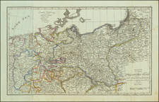
Official Wehrmacht Mapping of Transport Routes in the Soviet Union during the Opening Stages of Operation Barbarossa.
Very large and detailed color-printed map produced for the General Staff of the German Army during the first months of the German invasion of the Soviet Union.
The map shows all of European Russia and some adjacent areas. Within the Soviet Union, there are exact renderings of roads (highways, main streets, roadways, etc.), railroads (heavy gauge, narrow gauge, electric; with a note that Russian gauge was different from that of the rest of Europe), footpaths, car ferries, pontoon bridges, car bridges, etc.
The map is marked in German: "For official use only!"
It seems that the map was originally prepared in 1940 and this example was printed in September of 1941.
An important document for understanding German military strategy in the first year of the war with the Soviet Union.
![[Fascist Organizations of Germany] Фашистские Организации Германии](https://storage.googleapis.com/raremaps/img/small/67801.jpg)
![[ Eastern Belarus, etc ] Partie de Lithuanie ou sont partie les Palatinats de Minsk, et Mseislaw, et les Seignries ou Terres de Rohaczow, Rzeczica, Zernobel, et partie des Duches de Novogrodeck Sewierski, et de Zernihow . . . 1666](https://storage.googleapis.com/raremaps/img/small/76213.jpg)