|
||

|

|
|

|
Stock# 78938
Description
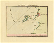
Attractive original antique navigational chart showing a harbor on an island just outside Toulon, in the south of France. The map names the fort and shows soundings, a shipwreck, and other useful coastal information.
The Port-Crose is located on the island of the same name, about eight miles south of Le Lavandou. A mostly uninhabited island, it was originally known as Messea by the ancient Greeks. It was a haven for pirates for a long time. Today, it is a French national park.
Rarity
The charts from Heather's New Mediterranean Pilot . . . are extremely rare on the market. This is the first example of the chart we have ever seen.