The item illustrated and described below is sold, but we
have another example in stock. To view the example which
is currently being offered for sale, click the
"View Details" button below.


|
||

|

|
|

|
Stock# 78937
Description
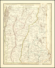
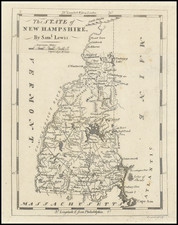
Rare state of this early map of New Hampshire, from Carey's Pocket Atlas. The map shows travel routes, towns, topography, rivers, and harbors. This map was based on surveys conducted by Samuel Lewis.
Carey published his American Atlas in 1795, which became the first folio atlas published in America. He issued later General Atlases in 1796 and after. In 1814, he became the first American publisher to offer hand coloring. Highly detailed map, showing towns, rivers, roads, counties, colleges, mills, forts and other details. An essential map for New Hampshire collectors.
Condition Description
Minor offsetting.