
![[ Greece and its Islands ] A New & Accurate Map of the Islands in the Archipelago, together with the Morea, and the Neighbouring Countries in Greece &c . . . By Emanuel Bowen](https://storage.googleapis.com/raremaps/img/small/84660.jpg)


|
||

|

|
|

|
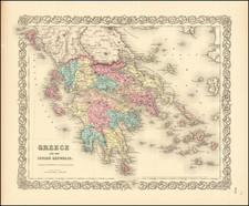
Detailed map of the Greek Islands and contiguous islands and regions, printed by Emmanuel Bowen for Innys and Richardson's A complete atlas, or, Distinct view of the known world. . .. This very attractive map shows Greece south of Macedonia, including detail on the regions of Albania and even the southeasternmost tip of Italy.
Relief is shown pictorially, and many towns and features of interest are noted. A dashed line indicates the border between Asia and Europe. This map includes a large cartouche and compass rose.
The map was published at the start of the Greek push for independence, which would culminate with a declaration of independence in 1821. Support for an independent Greece was particularly important in England, where Romantic poets including Lord Byron joined the independence effort.
Emanuel Bowen (1694?-1767) was a British engraver and print seller. He was most well-known for his atlases and county maps. Although he died in poverty, he was widely acknowledged for his expertise and was appointed as mapmaker to both George II of England and Louis XV of France. His business was carried on by his son, Thomas Bowen. He also trained many apprentices, two of whom became prominent mapmakers, Thomas Kitchin and Thomas Jeffreys.
![[ Geological Map of Greece ] Geognostisch-Bergmannische Karte von dem Konigreiche Griechenland zus Ammengestellt von Dr. Karl Gustav Fielder Königl: Sächs: Berg-Commissair, Director der Königl: Griechn. Gebirgsuntersuchung 1834 bis 1837, Ritter des goldnen Kreuzes des Erlöser-Ordens u.s.w. 1840](https://storage.googleapis.com/raremaps/img/small/96346.jpg)

![(Atlas of the Aegean -- Extra Illustrated!) L'Egeo redivivo o' sia chorographia dell' arcipelago, e dello stato primiero, & attuale di quell' isole. . . [The Aegean revived, or the chorography of the archipelago, and of the original and current state of those islands. . .]](https://storage.googleapis.com/raremaps/img/small/93229.jpg)