
The item illustrated and described below is sold, but we
have another example in stock. To view the example which
is currently being offered for sale, click the
"View Details" button below.


|
||

|

|
|

|
Stock# 7889
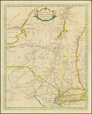
Description
Full color example of this scarce map of New York, extending from Long Island and NYC up to Lake Champlain and west along the Mohawk River to Lake Erie. Nice detrail, throughout, including the Partition Line of 1769 and a number of early forts. A few early roads are shown on Long Island. Moderately toned from and early framing, with repairs on the verso (non-archival). Normally a $450.00 map.