The item illustrated and described below is sold, but we
have another example in stock. To view the example which
is currently being offered for sale, click the
"View Details" button below.


|
||

|

|
|

|
Stock# 78888
Description
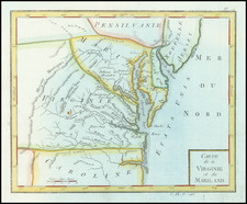
Fantastic original antique map of Virginia, Maryland, and other states on the eastern seaboard from the mid-18th century. This map was published in Paris by Joseph de Laporte immediately after the creation of the United States, which are mentioned in the Atlantic as "Etats Unis."
The map contains odd boundaries, with Maryland being particularly ill-defined. The map is strange for its deviation from the then-commonly accepted Fry and Jefferson cartography of the state, with unusual features added such as the "Tabaco Mountains."
In all, an unusual and uncommon map. This is the first time we have handled an example of the map.
Condition Description
Minor fold wear.
![[Amherst County Survey of 200 Acres Owned by Captain James Dillard dated 16, 1822]](https://storage.googleapis.com/raremaps/img/small/73745.jpg)