This item has been sold, but you can enter your email address to be notified if another example becomes available.


|
||

|

|
|

|
Stock# 78823
Description
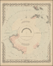
Very detailed map of the south polar regions, illustrating the great precision of Stieler's work.
Remarkable amount of explorer details, including:
- Cook 1772-75
- Bellinghausen 1819-21
- Wedell 1822-23
- Biscoe 1830-32
- Kemp 1834
- Ballen 1839
- D'Urville 1838-40
- Wilkes 1839-40
- Ross 1840-43
- Moore 1845
- Nares 1874
- Larsen: 1893
- Chun 1898-99
- De Gerlache 1898-99
- Borchgrevink 1899-1900
- Drygalski 1901-03
- Bruce 1902-04
- Nordenskjold 1902-04
- Scott 1901-04
The map is ringed with more than a dozen inset maps, showing mostly Islands in the Southern most part of the hemisphere.
![[ Charting Hall's Quest For The North Pole ] Die Entdeckungen der Amerikanischen Nordpolar-Expedition unter Kapitan C.F. Hall 1871-1873. Reduction der vom Hydrographic Office, U.S. Navy harausgegebenen grossen Karte.](https://storage.googleapis.com/raremaps/img/small/98478.jpg)
![[Glaciers & Polar Ice Packs, etc.] Arctic Ocean Greenland](https://storage.googleapis.com/raremaps/img/small/79033.jpg)