|
||

|

|
|

|
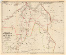
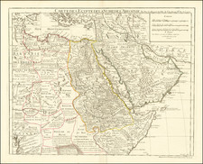
Attractive original antique map of East Africa, showing this part of the continent from the fourth and fifth cataracts down to the hypothesized sources of the Blue and White Niles. Major trading and explorers' routes are colored, and numerous other geographical features are shown. Detail extends into western Yemen and the southern part of modern Saudi Arabia.
This work originally appeared in Carl Ritter and F. O'Etzel's Hand-Atlas von Afrika. Carl Ritter is considered one of the founders of modern geography and was an important figure of his time. One of Ritter's best-known works, his Erdkunde im Verhaltnis. . ., attempted to describe the geography of the entire globe. This work had a very broad concept of geography, not only encompassing cartography but also hydrography, climatology, and volcanology. Ritter never completed his work due to the vast scale of his undertaking. His work was important in updating the mapping of the African interior.
![IX. b [East Africa]](https://storage.googleapis.com/raremaps/img/small/93300.jpg)