|
||

|

|
|

|
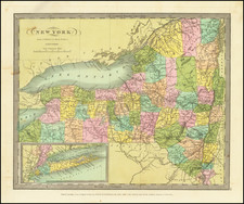
Original antique plan of the major canals and lakes that criss-cross New York State. This wide map centers on the all-important Eerie Canal, showing elevation changes between Lake Eerie and the Hudson River.
Shooting off of the main branch of the waterway are a number of other canals, including the Genesee Valley Canal, the Champlain Canal, and the Chenango Canal. Each of these has an associated table that describes the history and cost of the canal, as well as any locks that operate.
This plan and the numerous annotations take up the majority of the plate. In the lower right, there is an inset map of New York State, divided according to county and focusing on the hydrography of the region. All the canals named are shown, as are railroads.
This map was commissioned by William Taylor, State Engraver and Surveyor, and designed by his deputy S. H. Sweet. This map was updated throughout the 1860s and 1870s, with the current edition dating from 1865.
![[Early Saratoga County Land Indenture] Robert C. Livingston to Daniel D'Wolf Leases](https://storage.googleapis.com/raremaps/img/small/90872.jpg)