The item illustrated and described below is sold, but we
have another example in stock. To view the example which
is currently being offered for sale, click the
"View Details" button below.


|
||

|

|
|

|
Stock# 78776
Description
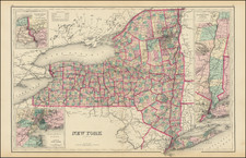
Large format and highly detailed antique lithographed map of the state of New York, colored by counties, by O.W. Gray.
The map shows, townships, towns, roads, railroads, rivers, mountains, canals, and a host of other details.
There are large insets of the Hudson River from New York City to Saratoga Springs, the Vicinity of New York City, and Niagara River and Vicinity.
Condition Description
Original hand-color. Faint centerfold toning.
O.W. Gray Biography
O. W. Gray was a publishing firm based in Philadelphia. Later, they published as O. W. Gray & Son. They published atlases in the late nineteenth century. Gray's National Atlas was one of the most successful commercial ventures of the 1870s and one of the last to employ hand coloring on maps.
![[Cyclist Atlas]](https://storage.googleapis.com/raremaps/img/small/88491.jpg)
![Map of the State of New York with Part of Upper Canada [Large inset plan of New York]](https://storage.googleapis.com/raremaps/img/small/91848.jpg)