|
||

|

|
|

|
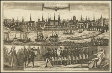
The Benjamin Eastburn / Nicholas Scull Plan of Philadelphia
Fine example of the extremely rare French edition of Benjamin Eastburn's (but in fact Nicholas Scull's) map of Philadelphia.
Originally published in London by Andrew Dury in 1776, the so-called "Benjamin Eastburn map" is in actuality drawn from Nicholas Scull's map of the City, drawn in 1762, while Scull was surveying as Surveyor General of Pennsylvania. The Scull map is of the utmost importance, with Snyder referring to the map as "The first detailed map of the interior of the city ... completes his great contribution to Philadelphia iconography"
Apparently, Dury mistook Eastburn, who had been dead for 30 years and whose earlier map appeared as one of two insets on Scull's more modern map, as the true maker of the map, although omitting the insets from his edition of the map, which was in turn copied by Le Rouge, with the perpetuation of Dury's misattribution compounded by a mis-spelling of the name.
The map shows the layout of the city along the Delaware River with a western orientation. It extends as far inland as Eighth Street, indicating and naming each major building. Along the waterfront, several wharves are named.
The key at right identifies 23 locations.
Rarity
The map is very rare on the market. This is the second example of the map we have offered in the past 20 years.
![[ Plasterers Company -- Certification of Master Plasterer Edward Evans ]](https://storage.googleapis.com/raremaps/img/small/97322.jpg)