|
||

|

|
|

|
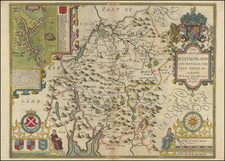
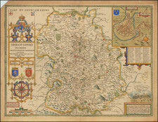
Fine original antique map of County Durham in northernmost England. The map shows the region in fine detail and with decorative elements typical for the Dutch Golden Age of Cartography. This map was published by William Janszoon Blaeu in Amsterdam as part of a series of maps showing the British counties.
County Durham, centered on the ancient city of Durham, home to its eponymous cathedral and the third oldest English university, is a traditional independent part of the country, having traditionally been governed by bishops. It is sandwiched next to the North Sea adjacent to the counties of Northumberland and the North Riding of Yorkshire, and its many rolling hills are apparent on this map. Walled gardens, termed parks, show lands associated with aristocratic ownership and outside the realm of common usage.
Decorative elements on the map abound, with sailing ships, a compass rose, the royal coat of arms featuring a unicorn and lion, and a cartouche showing two shepherds.
Willem Janszoon Blaeu (1571-1638) was a prominent Dutch geographer and publisher. Born the son of a herring merchant, Blaeu chose not fish but mathematics and astronomy for his focus. He studied with the famous Danish astronomer Tycho Brahe, with whom he honed his instrument and globe making skills. Blaeu set up shop in Amsterdam, where he sold instruments and globes, published maps, and edited the works of intellectuals like Descartes and Hugo Grotius. In 1635, he released his atlas, Theatrum Orbis Terrarum, sive, Atlas novus.
Willem died in 1638. He had two sons, Cornelis (1610-1648) and Joan (1596-1673). Joan trained as a lawyer, but joined his father’s business rather than practice. After his father’s death, the brothers took over their father’s shop and Joan took on his work as hydrographer to the Dutch East India Company. Later in life, Joan would modify and greatly expand his father’s Atlas novus, eventually releasing his masterpiece, the Atlas maior, between 1662 and 1672.