


|
||

|

|
|

|
Stock# 78733
Description
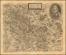
Fine original antique map published by Peeter van den Keere at the start of the 17th century, showing the region of Westphalia along the Rhine River in northwestern Germany.
The map shows a number of cities in the region in detail and includes a number of other fascinating features, such as forests, mountains, rivers, and more. Cities shown include Duisburg, Dusseldorf, Cologne, and Bonn in this today-highly industrialized and economically important part of the country.
The region was, at the time, part of the Holy Roman Empire, which was in the midst of the devastating Thirty Years' War, fought over religious and ethnic differences throughout Europe.
![[Napoleon's Battles in France, Belgium Netherlands, Luxembourg, Germany] No. 1 Frontiere du Nord. Mesny 5.](https://storage.googleapis.com/raremaps/img/small/60727.jpg)