


|
||

|

|
|

|
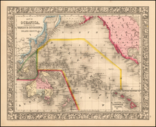
Antique map of four different Pacific island groups.
The Hawaiian Islands are labeled with two transcriptions each of their names; there were some spelling discrepancies in early writings. In A Voyage to the Pacific Ocean, Captain James Cook gives Kauai four spellings: "Atooi, Atowi, or Towi, and sometimes Kauai" and Kaho‘olawe is "Kahowrowee, or Tahoorowa".
A line divides Papua New Guinea, with the western half claimed by the Netherlands as New Guinea (Nederlands-Nieuw-Guinea). The mapmaker notes, "The Interior of New Guinea is totally unknown (1856)." The Aird River, the only river shown on the southeastern coast, is mapped along with a note that the "Low Coast [is] intersected by numerous large fresh water channels".
In the Solomon Islands, Point Cruz, now a part of the capital Honiara, is mapped.

![[Hawaii] Carte Des Parties Des Iles Sandwich . . . 1786](https://storage.googleapis.com/raremaps/img/small/81545.jpg)