|
||

|

|
|

|
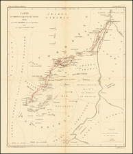
Attractive original antique map of the northern coastline of Africa between Alexandria and Tunis, printed in Berlin by Carl Ritter. This map shows the topography and geography of the region in an attractive modern style, and in color denotes the routes of early explorers and military leaders from the late 18th and early 19th centuries.
An inset in the upper right shows the remnants of ancient Carthage in detail, naming nineteen places of interest and showing the city's walls, aqueducts, and other features. The map is constructed in Ritter's typical style, and focuses on providing as much accurate and up-to-date information as possible while citing some of its sources.
Carl Ritter and Modern Geography
Carl Ritter is considered one of the founders of modern geography and was an important figure of his time. One of Ritter's best-known works, his Erdkunde im Verhaltnis. . ., attempted to describe the geography of the entire globe. This work had a very broad concept of geography, not only encompassing cartography but also hydrography, climatology, and volcanology. Ritter never completed his work due to the vast scale of his undertaking.
![[Christian Conquest and Fortification of Djerba in 1560] Aviso Del Successo Del Arm'ata De Christiani che si truova in Barberia, & della presa del Gerbi diretta al. S. Comendator Cambiano dal S. Paulo de la gesia Comedator; et secretario del R.S. gran Mastro de la religion de Rodi, Molto Magnifico S. Miro.](https://storage.googleapis.com/raremaps/img/small/61878.jpg)

![[ The Honorable Kingdom of Morocco ] المملكة المغربية الشريف](https://storage.googleapis.com/raremaps/img/small/96404.jpg)