|
||

|

|
|

|
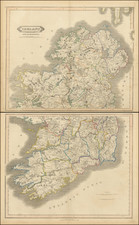
Fine two-sheet map of Ireland, published in 1665 by Nicolas Sanson, the leading French cartographer at the time. The maps are very detailed, including showing the many loughs and rivers of the island. Relief is shown pictorially.
The map is colored according to the historical provinces of Ireland, with Ulster colored in red, Connaught in yellow, Leinster in green, and Munster again in red. The upper map, showing the northern portion of Ireland, shows the country about as far south as Dublin, while the lower map shows the rest.
In all, a very nice map of Ireland.
Nicholas Sanson (1600-1667) is considered the father of French cartography in its golden age from the mid-seventeenth century to the mid-eighteenth. Over the course of his career he produced over 300 maps; they are known for their clean style and extensive research. Sanson was largely responsible for beginning the shift of cartographic production and excellence from Amsterdam to Paris in the later-seventeenth century.
Sanson was born in Abbeville in Picardy. He made his first map at age twenty, a wall map of ancient Gaul. Upon moving to Paris, he gained the attention of Cardinal Richelieu, who made an introduction of Sanson to King Louis XIII. This led to Sanson's tutoring of the king and the granting of the title ingenieur-geographe du roi.
His success can be chalked up to his geographic and research skills, but also to his partnership with Pierre Mariette. Early in his career, Sanson worked primarily with the publisher Melchior Tavernier. Mariette purchased Tavernier’s business in 1644. Sanson worked with Mariette until 1657, when the latter died. Mariette’s son, also Pierre, helped to publish the Cartes générales de toutes les parties du monde (1658), Sanson' atlas and the first French world atlas.
![[Hungarian Map of Great Britain] Nagy Britannia](https://storage.googleapis.com/raremaps/img/small/85219.jpg)
![[Leinster County, Ireland] Comitatus Lageniae -- The Countie of Leinster](https://storage.googleapis.com/raremaps/img/small/23554.jpg)
![[Youghal] The Towne of Youghall](https://storage.googleapis.com/raremaps/img/small/83704.jpg)