|
||

|

|
|

|
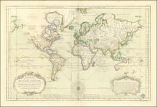
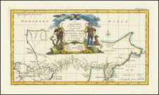
Old Color Example of Buache's Experimental Single-Hemisphere World Map With Early Example of Sea of the West
A very unusual map of the world, which was engraved to augment Buache's Considérations géographiques et physiques, one of his most important and original cartographic works.
This map projects the continents of the Southern Hemisphere over the continents of the Northern Hemisphere in order to better visualize the three-dimensional nature of the globe. Buache's goal was to portray the world as if it was transparent, as he explains in the text column to the left of the hemisphere. The projection also helps to understand the spread of the continents over the world, a topic of enduring importance thanks to the continued theorizing about a southern continent by eighteenth-century geographers. Buache is particularly impressed with how far North Cape Horn stretched when compared to the northern hemisphere.
Buache's map is discussed in depth by Geography Geek here.
Buache goes to explain that the world as seen here clearly has six sectors. These consist of three large islands: the Americas, Australia and the islands of Southeast Asia, and the Asia/Africa/Europe continental confluence. These three landmasses correspond to three reservoirs: the Pacific (South Seas or Grand Ocean), the Indian Ocean, and the Atlantic. He thought the mountains of the continents, and particularly those he thought were possibly part of a southern continent, re-emerged from the sea to form other continents and create streams for water to flow-the framework of the globe. This was an early explanation of his larger ideas about watersheds, a concept he expanded on in other geographic works, like this map (see here ).
Buache's Geography of the Pacific Northwest
The Pacific Northwest has a feature that appears odd to modern eyes-the Sea of the West in the interior of North America. This sea had first appeared on charts published by Johann Baptiste Nolin in ca. 1700, but had quickly disappeared thereafter. Although the great French geographer Guillaume De L'Isle never published a map showing the sea, he had postulated that it could exist, and that it might connect to a Northwest Passage through New France, not through English territory farther north. Nolin had plagiarized the idea from Guillaume, as the latter testified when suing the former for plagiarism. He said, the Sea of the West "was one of my discoveries. But since it is not always appropriate to publish what one knows or what one thinks one knows, I have not had this sea engraved on the works that I made public, not wanting foreigners to profit from this discovery" (as quoted in Pedley, 109).
The Sea of the West began to appear again in the 1740s, with this map, and most famously in 1752 when Joseph-Nicolas Delisle, Guillaume's brother, and Buache, his son-in-law, published a map showing the Russian discoveries in the far north Pacific. Buache had reviewed his father-in-law's papers and read of the Sea of the West. He and his uncle included the sea on their maps and the feature spread to other maps thereafter. To learn more of the 1752 map, see here .
The entrances to this sea are also interesting. Buache includes the Entrée de Fuca and the Detroit de Aguilar. Martin Aguilar was a Spanish captain who sailed with Sebastian Vizcaino on a reconnaissance expedition up the California coast in 1602-3. Aguilar, commanding the Tres Reyes, was blown off course, to the north. When the seas calmed, Aguilar reported that he had found the mouth of a large river. Eighteenth-century geographers, including Bauche, conjectured that the river was the entrance to the Sea of the West, as it is positioned on this map.
There is another entrance to the sea, this one labeled as the discovery of Juan de la Fuca, which refers to Juan de la Fuca, the Castilianized name of Greek navigator Ioánnis Fokás (Phokás). Little archival evidence survives of Fuca's career, but a chance meeting with an English financier, Michael Lok, in Venice in 1596 gave birth to rumors of Fuca's voyages in the Pacific. Fuca reported that he had been sent north from New Spain twice in 1592 in search of the Strait of Anian. The Spanish Crown failed to reward Fuca's discovery of an opening in the coast at roughly 47° N latitude and Fuca left the Spanish service embittered. His story lived on in Lok's letters and eventually was published in Samuel Purchas' travel collection of 1625. On many eighteenth-century maps, including this one, Fuca's Strait is linked with a River or Sea of the West. In 1787, the present-day Juan de Fuca Strait was named by the wife of naval explorer Charles William Barkley, making permanent a label that had previously just been hopeful conjecture.
Mary Sponberg Pedley, The Commerce of Cartography: Making and Marketing Maps in Eighteenth-Century France and England (Chicago: University of Chicago Press, 2005).
H. R. Wagner, "Apocryphal Voyages to the Northwest Coast of America," Proceedings of the AAS XLI (1931): 179-234.
Philippe Buache (1700-1773) was one of the most famous French geographers of the eighteenth century. Buache was married to the daughter of the eminent Guillaume Delisle and worked with his father-in-law, carrying on the business after Guillaume died. Buache gained the title geographe du roi in 1729 and was elected to the Academie des Sciences in the same year. Buache was a pioneering theoretical geographer, especially as regards contour lines and watersheds. He is best known for his works such as Considérations géographiques et physiques sur les découvertes nouvelles dans la grande mer (Paris, 1754).
![[ World & Continents ] Typus Orbis Terrarum / Americae Sive Novi Orbis Nova Descriptio / Asiae Nova Descriptio / Africae Tabula Nova / Europae](https://storage.googleapis.com/raremaps/img/small/99250.jpg)