|
||

|

|
|

|
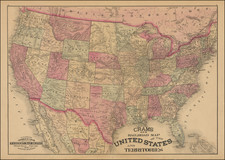
Unusual State of Deseret Configuration of Utah Territory
Nice example of Flemming's map of the United States, exhibiting in fabulous detail the early US territorial borders, forts, and other details.
The map includes a very unusual tomahawk-shaped Indian Territory and massive Minnesota Territory. California is very reduced in size. The map includes excellent topographical details, some real, some conjecture.
The map predates the split of Oregon Territory into Oregon and Washington and the Gadsden Purchase, but shows both Utah and New Mexico, indicating that it was issued sometime around 1850.
Deseret
One of the primary features of interest on this map is the configuration of the Utah Territory, which comprises all of Nevada and Arizona, as well as large parts of Colorado, New Mexico, and California. Los Angeles and San Diego are even shown as part of this territory. Usually, when this configuration is displayed on a map, it is referred to as a hypothetical "State of Deseret," a state proposed in 1849 by Mormon settlers. However, the Utah Territory was created instead during the Compromise of 1850, although with a very different boundary than that shown here. This map retains the largest Deseret configuration, but names it "Utah Territ." in the key in the lower-left.