|
||

|

|
|

|
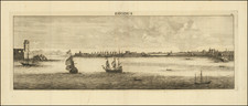
Original antique navigational chart of the harbor on the southern portion of the island of Cythera, in Greece. This map was produced by William Heather for his New Mediterranean Pilot. . .
The chart shows a bay with numerous depth soundings, with coastal detail, and showing a fort and the town of St. Nicholas. Serigo, or Cerigo, is the traditional name for the island Cyritha, in Greece. While possessing some differences, this port looks most similar to the port near Kythira and Kapsali on the southern part of the island. The island itself is located just off the south coast of the Peloponnesian Peninsula.
Rarity
The charts from Heather's New Mediterranean Pilot . . . are extremely rare on the market. This is the first example of the chart we have ever seen.
![[Greece & Turkey] Tabula Europae IX](https://storage.googleapis.com/raremaps/img/small/60122.jpg)