


|
||

|

|
|

|
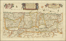
Scarce 17th Century English map of the Holy Land, published by Joseph Moxon in London.
The map show the wandering of the "Children of Israel," following their exodus from Egypt. The map appeared in Moxon's Sacred Geographie or Scriptural Mapps.
Oriented with west at the top, the map shows the exodus of the Jews from Egypt 40 years wandering in the desert. At the bottom, the map shows iconic images including vessels from the Temple, a plan of the Jews’ encampment alongside the Tabernacle and images of Moses and Aaron.
Moxon dedicates the map to "To his Grace James Duke of Ormond.”
Within the map there are a host of miniature scenes from the bible, including:
- Pharaoh and all of his host following Israel is drowned in the Sea
- Quails come flying from the Sea
- The Israelites dance about the molten Calf
- Moses receives the Law
- Miriam sent out
- The Brazen Serpent lift up by Moses
- Aarons Grave Mount Hor;
The regions identified with each of the 12 Tribes are shown.
Moxon credits a map (first published in 1657) by famed Dutch publisher Nicolas Visscher in Amsterdam as his source. At this time in London, referencing a Dutch or French source for the cartographic content of a map brought credibility, as the London map trade was still very much in its infancy.
![[The Travels of Paul] Tabula Geographica, in qua omnes regiones, urbes, oppida, et loca describuntur, quorum mentio fit in Actis et Epistolis Apostolotum, et Apocalypsi; de integro multis in locis emendata, ac regionum limitibus distincta, auct. Pet. Planc. . . .](https://storage.googleapis.com/raremaps/img/small/77970.jpg)
![Syria (North Division) [with] Syria (South Division) including Palestine & the Hauran.](https://storage.googleapis.com/raremaps/img/small/89072.jpg)