


|
||

|

|
|

|
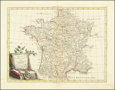
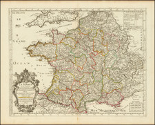
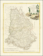
Buache's Theory of Undersea Mountains, with His Representation of the Drainage Basins of France
Fine and interesting example of Buache's map of the French watersheds, displaying some of his more intriguing theories including the one that the continents of the world are connected by undersea mountain ranges. This map was published in Paris in 1770, during the enlightenment at a time when many new ideas regarding geographical and scientific discoveries were being made.
The map primarily shows the various drainage basins of the country, which are divided according to what Buache believes to be the most important mountains and chains of hills. This idea was the forefather for the modern concept of watersheds in which certain areas all have the same general flow direction, and is now important for understanding how ecosystems work.
Underneath the English Channel, connections are shown as well as various depths of "terraces" that were based on Buache's theory as to how the continents were related.
This work was based on the memoirs presented to the Royal Academy of Science in 1752 and 1757 that discuss physical geography. This example of the map was executed by Dezauche following Buache.
Philippe Bauche, theoretical geography, and thematic mapping
Buache was a pioneering theoretical geographer interested in demonstrating the interconnectedness of the world’s landmasses. Starting in 1737, Buache drew a bathymetric map of the English Channel which showed "hidden features" of the channel that argued that mountain chains of England (the Pennines and South Downs) could be connected to the Alps through the straits of Dover. Two decades later, he would expand his map to cover the whole world.
Buache was also interested in watersheds, which he argued were created by interlinked mountain ranges which circled the globe. These mountain ranges provided routes for rivers to flow to the sea. Buache understood islands to be proof of mountain ranges that connected the continents. Buache presented this mountain chain idea at the Academie first in September 1737 and again in November 1752, once he had completed his worldview.
This is thought to be one of the first thematic maps, which appeared in the same decade as other famous thematic maps, such as De Lisle's first geological maps. A similar world map would also accompany Buache’s published essay on the subject, An Essay of Physical Geography, wherein it is proposed to present General Views on what may be called the Framework of the Globe, composed of mountain systems that cross seas as well as continents; with some particular remarks on the different basins of the sea, and on its interior configuration (1752).
Philippe Buache (1700-1773) was one of the most famous French geographers of the eighteenth century. Buache was married to the daughter of the eminent Guillaume Delisle and worked with his father-in-law, carrying on the business after Guillaume died. Buache gained the title geographe du roi in 1729 and was elected to the Academie des Sciences in the same year. Buache was a pioneering theoretical geographer, especially as regards contour lines and watersheds. He is best known for his works such as Considérations géographiques et physiques sur les découvertes nouvelles dans la grande mer (Paris, 1754).
Jean-Claude Dezauche (fl. 1780-1838) was a French map publisher. Initially, his work focused on engraving music, but he later turned primarily to cartography. His is best known for editing and reissuing the maps of Guilluame De L’Isle and Philippe Buache, two of the most skilled mapmakers of the eighteenth century. He acquired the plates of these two men’s work in 1780 from Buache’s heir, Jean-Nicolas Buache. Dezauche's business received a further boon when he received a privilege to sell the charts of the Dépôt de la Marine. His business was carried on by his son, Jean-Andre Dezauche.
![[ Holy Roman Empire, Poland, Baltic, etc. ] Germania VI Nova Tabula (First state!)](https://storage.googleapis.com/raremaps/img/small/94645.jpg)
![(France, Belgium, and Holland) Tabula Moderna Francie [Modern Map of France]](https://storage.googleapis.com/raremaps/img/small/101885.jpg)
![(Napoleon III) Camp De Chalons - Sur - Marne / Plan du Terrain Affecte au Camp et Des Terrains Environnans Leve par les Officieres du Genie Paris 1857 [with military movements added by hand]](https://storage.googleapis.com/raremaps/img/small/65093op.jpg)