|
||

|

|
|

|
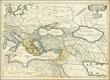
The Land Between the Tigris and the Euphrates. A Western European Look at the Mandean Sect.
Fantastic original antique map of the lower Tigris and Euphrates Rivers down to Basrah, published in France but containing Arabic toponyms and other regional stylistic tendencies. The map was originally published in 1663 in Thevenot's Relations de Divers Voyages Curieux, a French translation of Hakluyt, Purchas, and other explorers.
The map focuses on a region of present-day Iraq, adjacent to the Tigris, which was a center for the Mandean Judeo-Christian sect. They are referred to on the map as "Familiarum Christianorum Sancti Johannis," which refers to their reverence of John the Baptist above all, which led western observers to label them as a hitherto unknown Christian population.
The map is notable for its use of the Arabic language in naming the various towns and cities on the map. In addition, the legend that provides the romanticized names for all these places reads right to left, and the estimated number of Mandean families in each region is provided.
The western understanding of the Mandeans, for which this map is an important source, were based on the Mandeans' reverence of certain Christian figures as well as their baptismal practices. They are, in fact, a Gnostic sect surviving in the region shown that practices religion in a manner which appears akin, but which diverged in about the first century A.D. As such, they provide a useful modern understanding of the early evolution of Christianity.