|
||

|

|
|

|
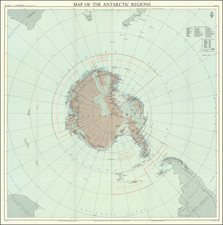
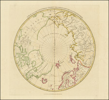
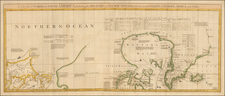
Polar Exploration Immediately Prior To Peary's Reaching The North Pole
Edward Stanford's rare map depicting the entire Arctic Region, featuring the furthest-most points reached by numerous exploring expeditions.
This fascinating map embraces the entire Arctic regions of the World, within a unique ovoid presentation. Centered on the North Pole, it variously extends as fare south as 50 to 55 degrees North. All countries are distinguished by their own colors, and major geographic and oceanic features are labeled. The map was updated annually or perhaps even more often to show the latest explorations in red, here ending with a number of Peary discoveries up to 1901 and several more discoveries in 1902 and 1903, including the Russian polar expedition of 1900–1902commissioned by the Saint Petersburg Academy of Sciences to study the Arctic Ocean north of New Siberian Islands and search for the legendary Sannikov Land, led by the Baltic German geologist and Arctic explorer Baron Eduard von Toll on the ship Zarya. Toll and his three assistants vanished in late 1902 while exploring Bennett Island. Alexander Kolchak, then a young researcher and lieutenant of the Russian Navy led the rescue mission to find Toll and his crew.
Most interesting, is the labeling of the furthest-most points of literally dozens of expeditions of discovery, along with the corresponding dates (printed in red). These extend chronologically from Sebastian Cabot's supposed visit to northern Newfoundland in 1497 to the Russian discoveries in 1902-03. All the great names are mentioned, including Frobisher, Davis, Hudson, Baffin, Barents, Bering, Franklin, Nordenskjold, Ross and Peary, amongst many others. The American portion of the Bering Sea is labelled with information on the seasonal fishing restrictions. The amount of information featured on the map is truly extraordinary, and is unrivalled by any Arctic map of comparable size.
The map was issued around 1905 by Edward Stanford, then Britain's leading map publisher, in an effort to capitalize on the great contemporary interest in Polar expeditions, seen as the 'last frontier' in global exploration. Stanford had good connections with academic institutions such as the Royal Geographical Society and government bodies such as the Admiralty, so was always able to gain the most accurate information. The present map was one of Stanford's series of progressively updated maps of the Arctic Regions, the first of which was published around 1894, and the last issued in the 1930s.
Rarity
This map is scarce, as are all other issues of Stanford's Arctic series.
We can find only one example in institutional collections, at the Bibliothèque national de France (Paris).