All of our maps are authentic antique maps, printed or drawn on or about the date shown in the description. In rare instances when we offer facsimiles, we will specifically describe the map as a later facsimile and include the date of publication. Certificates of Authenticity are included with each item.
Map Maker
Fast, Global Shipping
Last year we shipped over 4,500 antique maps to more than 50 countries. Maps are shipped Monday through Friday year-round. If an order is received before 2 PM PST, we will ship the order that day. If an order is received after that time, we will ship the next day. We ship maps either flat in custom packages or in specially ordered thick tubes. Shipping rates are provided as part of the checkout process.
Description
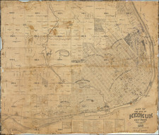
Early map of Iowa, published by Thomas Cowperthwait & Company.
The map is hand colored by counties, showing railroads, stage lines, canals, roads, rivers, lakes, forts and other details.
Perhaps the best map of Iowa from the early 1850s.


![[Missouri, Illinois, Indian Territory, Kansas, Nebraska, Iowa] Amer. Sep. No. 49. Partie des États Unis](https://storage.googleapis.com/raremaps/img/small/74904.jpg)
![Muster roll of N.C. Officers, [XXXXX] + Privates employed on Extra duty, as Laborers in constructing a Public road on the West bank of the Mississippi, during the Months of June + July 1841. By order of B[revetted] B[rigadier] G[eneral] Brooke](https://storage.googleapis.com/raremaps/img/small/72401.jpg)
![[ McGregor, Iowa ] Bird's Eye View of the City of McGregor and North McGregor 1869 . . . .](https://storage.googleapis.com/raremaps/img/small/73658.jpg)