


|
||

|

|
|

|
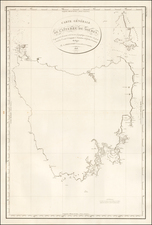
Wyld's Large Map of the Settled Parts of Australia, Featuring Discoveries from Recent Expeditions into the Interior.
Wyld's fascinating map depicting all of the settled areas of Australia as they appeared in the early 1840s. The main map embraces the area of the modern states of New South Wales, Victoria and South Australia, while detailed insets feature Western Australia and Tasmania. This map was published by James Wyld at his Charing Cross, London address.
Most of the settlement is concentrated in two regions, the roughly eighteen counties in New South Wales (which then included all of Queensland) centered around Sydney and the twenty-six counties centered around Perth in Western Australia. The border between South Australia and New South Wales is the only one defined, and Victoria remains an unorganized territory called 'Australia Felix', shown more than a decade before the gold rush.
The map also includes insets of Sydney, Adelaide, and Van Diemens Land (with Western Australia also being inset). Van Diemen's Land (later Tasmania) shows development in its eastern regions with nine counties having been laid out. Adelaide has a school, store, barracks, marketplace, and hospital, while Sydney is shown in extensive detail with individual buildings indicated and botanic gardens, various places of interest, and more all shown.
James Wyld was one of the world's leading mapmakers, holding the title of official Geographer to Queen Victoria. The present map is one of Wyld's sequences of continually updated maps of Australia and its regions, and these maps are of great historical importance for the definitive role they played in recording the rapid progress of exploration and development during Australia's formative years.
The Mapping of Australia
By the time of this map's publication, the coastlines of the subcontinent were well defined following the explorations of Matthew Flinders and others, however, a majority of the interior remained a complete enigma. Importantly the map depicts the recent discoveries of several explorers, especially with respect to the conspicuous detail in the interior of what in now Victoria and the far southern part of New South Wales.
On various treks from 1824 to 1828, Hamilton Hume discovered the overland route from Sydney to Port Philipp (the future site of Melbourne), as well as the Darling River, the Murray River's longest tributary. Knowledge of the Murray Basin and surrounding regions was expanded upon by the expeditions of Charles Sturt from 1828 to 1830 and Sir Thomas Mitchell from 1831 to 1836. Mitchell had previously been responsible for the mapping of the settled regions of New South Wales as shown on this map, an achievement for which he received his knighthood. Fittingly, the present map is dedicated to Mitchell.
States
Tooley lists six editions of the Wyld map of South Australia, as follows:
- Pre-1847. Lacking Port Albert, Albert Town, and other features.
- 1847-1848. Port Albert and Albert Town appear.
- Undated. Boundaries given to Victoria, Wimmera appears.
- Undated. Imprint now reads Jas Wyld Geographer to the Queen, Charing Cross East London & Model of the Earth Leicester Square
- Undated. Railways added below Gold Deposits. N.S.W now has a northern boundary.
- Undated. British Statute Miles added below title.
However, Tooley's states are unclear, our map has a line showing the British Statute Miles below the title, however, it does not name Port Albert in Corner Basin. As such, we tentatively date this as an early, pre-1847, state of the map, pre-dating the growth of Port Albert.

![Asia [with inset:] New Holland or Australia.](https://storage.googleapis.com/raremaps/img/small/98818.jpg)
![(Australia) Australien - Ubersicht des Standpunkets der geographischen Kenntniss von Australien, 1868, & Dr. Neumayer's Projeket zur wisseschaftlichen Erforschung Central-Australiens [Survey of the Standpoint of the Geographical Knowledge of Australia, 1868, & Dr. Neumayer's project for the scientific investigation of central Australia]](https://storage.googleapis.com/raremaps/img/small/85398.jpg)